
Maitland Local Spatial Development Framework (2024)
Information Sessions 13th and 17th July 2024
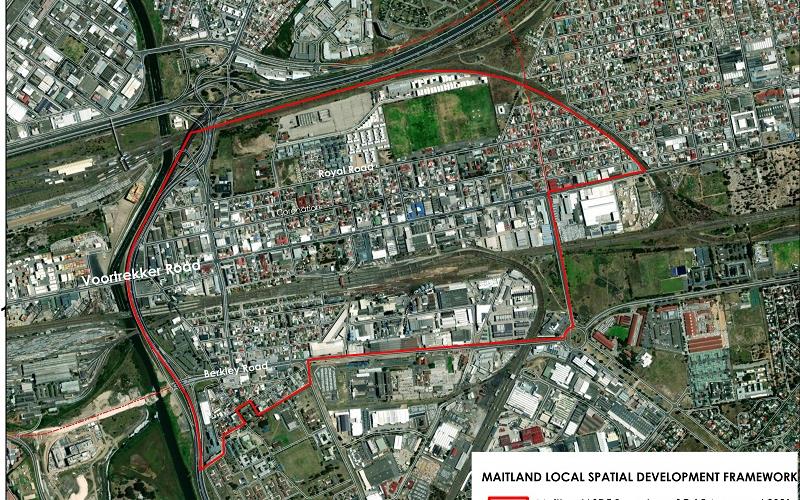
The City of Cape Town’s Council approved the local spatial development framework (LSDF) for Maitland on the 27th of March 2024. The LSDF was drafted in collaboration with the local community and business owners. The spatial vision intends to revitalise the area by guiding public infrastructure investment and unlocking developments that will assist with job creation, among others.
To access a digital copy of the approved LSDF visit the City’s website link here.
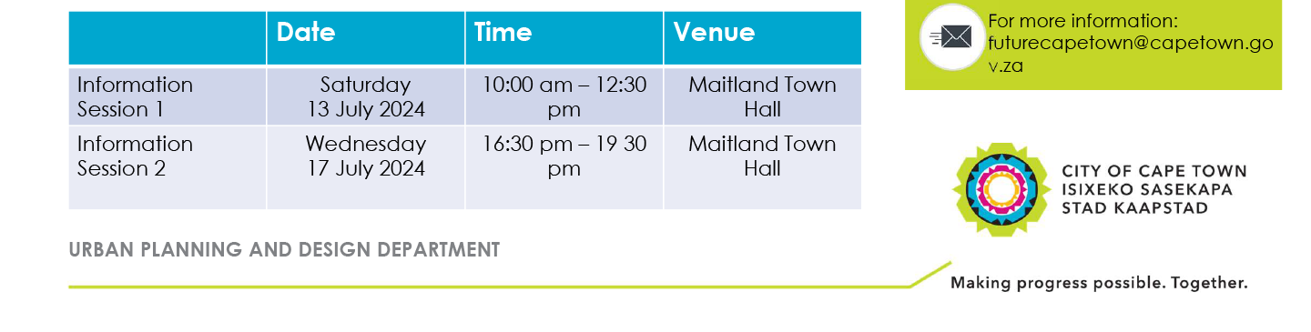
Maitland LSDF Information Sessions
The City of Cape Town’s Urban Planning and Design Department will host two information sessions on the Council approved local spatial development framework (LSDF) for Maitland that was approved by Council on the 27th of March 2024.
The two information sessions are planned for the 13th and 17th of July 2024 at Maitland Town Hall.
The now approved LSDF determines the development vision for Maitland on an area level. Going forward, the City will use the LSDF for guidance when making decisions about development applications and land uses; and in the end, these decisions will determine what Maitland will look and feel like a few years down the line.
The Maitland LSDF pursues a spatial vision that will assist with the regeneration of the area:
- Maitland represents the gateway to Voortrekker Road which is a development corridor and activity route; the Urban Development Zone along Maitland and Kensington offers an opportunity of urban regeneration with a diversity of mixed uses that will be supported by the first phase of the Voortrekker Road Streetscape and road widening.
- Prioritised, coordinated and sequenced City improvements of Maitland’s road infrastructure are important catalysts for urban regeneration and include the planned new MyCiTi bus station and proposed upgrade of Berkley Road. The projects will enhance and enable the movement of goods and people, and facilitate an improved public realm for better access supported by job generating activities. The City is currently sourcing comment from the public about the proposed upgrade of Berkley Road: capetown.gov.za/City-Connect/Have-your-say/Issues-open-for-public-comment/upgrade-of-berkley-road-in-maitland,
- Prioritising universally accessible and safe pedestrian movement
- Using the Black River as an asset to create new opportunities and improved access between Maitland and the river
- Improving access and connectivity with the creation of integrated and inclusive communal spaces
The LSDF also includes:
- Maps to reflect current and future elements such as road networks, public transport systems, public open spaces, and public facilities
- Land use management guidelines, guidance on improved connectivity and greater accessibility to support a high quality urban form and universally accessible public realm in line with transit orientated development
- The spatial proposals to improve the urban space, among which indicating areas where public and private development should be prioritised, and areas in need of strategic intervention to pursue the vision of a City of Hope for Maitland
- Key infrastructure requirements to enable the spatial vision have been prioritised, sequenced and phased as part of the implementation plan
- An implementation plan indicating City projects at a concept stage, and others that have been confirmed and those that are already underway to realise the spatial vision
- Technical input and analysis led by the City’s Urban Planning and Design Department, with input from City line departments, the Western Cape Government, National Ports Authority, Transnet and National Department of Public Works
The Maitland LSDF elaborates on and supports the spatial development guidelines as set out in the Table Bay District Spatial Development Framework, which is a higher order plan for the greater Table Bay area; and the City’s Municipal Spatial Development Framework that sets the overall spatial vision for Cape Town.
More information: https://www.capetown.gov.za/Media-and-news/Council%20approves%20new%20spatial%20vision%20for%20Maitland